The subsurface contrast between Kelowna's Lower Mission and the upper benches of Dilworth Mountain tells you everything about why seismic tomography matters here. Down by the lake, alluvial fan deposits from Mill Creek mask the transition from loose silts to the underlying metamorphic bedrock of the Monashee Complex, often hiding a weathered contact zone that standard drilling alone misinterprets. Up on the slopes, the same bedrock sits shallow beneath a thin veneer of glacial till—but it is fractured, water-bearing, and unpredictably irregular. Seismic refraction combined with high-resolution reflection profiling lets us trace that bedrock surface continuously between boreholes, measure the P-wave velocity of the weathered versus competent rock, and identify low-velocity anomalies that correlate with fracture corridors. In a city where the building code enforces rigorous NBCC site classification, the difference between a Class C and a Class E site can shift your foundation design by tens of thousands of dollars. Before finalizing excavation depths, it is worth integrating the seismic data with in-situ permeability measurements when groundwater pathways through fractured rock become a construction concern.
The weathered rock contact zone in the Okanagan Valley often exhibits a velocity inversion that refraction alone cannot resolve—combined refraction/reflection is non-negotiable here.
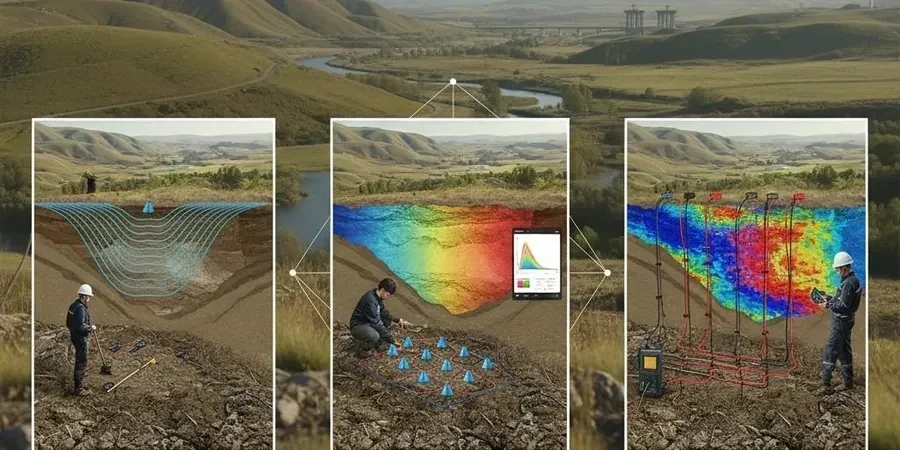
Regional considerations
A geotechnical reality in Kelowna that is often underestimated is the presence of infilled paleochannels cutting through the Okanagan Valley floor. These ancient stream beds, buried beneath up to 15 meters of glaciolacustrine silt, contain loose sand and gravel lenses that generate strong seismic velocity contrasts—and they are invisible from the surface. If a foundation design relies solely on a few boreholes spaced 30 meters apart, a narrow paleochannel can easily be missed, leading to differential settlement where the structure spans the transition from dense till to channel fill. The NBCC 2020 assigns Kelowna a moderately high seismic hazard, with a 2%-in-50-year PGA exceeding 0.25g in some site subclasses; an undetected low-velocity layer amplifies ground motion disproportionately. Seismic tomography provides the continuous lateral coverage that point measurements cannot, flagging these buried channels before the excavation reaches them. When the tomography reveals a depression in the bedrock profile deeper than the adjacent borehole data, our team typically recommends supplementing the investigation with CPT soundings to directly measure the tip resistance and pore pressure dissipation within the channel fill material.
Common questions
What depth of investigation can seismic tomography achieve in Kelowna's geology?
With a 120-meter spread length and sledgehammer source, the practical depth of investigation ranges from 15 to 35 meters below ground surface. The depth depends on the velocity contrast between the overburden and bedrock, and on the ambient noise level at the site. In the Mission area where thick silts overlie weathered gneiss, we typically resolve to 25 meters. In the upper benches where bedrock is shallower, resolution improves to within the top 15 meters with higher confidence. For deeper targets beyond 35 meters, a larger energy source such as a weight drop or accelerated weight drop system is required.
How does combined refraction and reflection differ from running refraction alone?
Refraction requires the seismic velocity to increase with depth—a condition that fails when a weathered, low-velocity rock layer sits beneath higher-velocity overburden, or when the water table creates a velocity inversion. Reflection does not have this limitation: it images acoustic impedance contrasts regardless of the velocity layering. In Kelowna, the weathered contact zone at the bedrock surface often exhibits exactly this velocity inversion, making the reflection component essential for mapping the true bedrock topography. The combination gives us both the velocity structure for rippability assessment and the geometric continuity of the bedrock reflector.
Can seismic tomography be performed on steep slopes or in tight urban lots?
Yes, but with specific adaptations. On slopes exceeding 25 degrees—common in the Upper Mission and along the benches—we use shorter geophone spacings of 2 to 3 meters and secure the geophones with sandbags or spikes to maintain coupling. The layback correction applied during processing accounts for the topography. In tight urban lots in downtown Kelowna or Pandosy Village, we configure the line as a non-linear spread or run multiple short lines that are merged during tomographic inversion. The sledgehammer source is well-suited to constrained spaces where larger mechanical sources cannot operate.
What is the cost range for a seismic tomography survey in Kelowna?
A typical seismic refraction/reflection survey for a residential or light commercial project in Kelowna, covering two to three profile lines with a combined length of 200 to 300 meters, falls in the range of CA$3,570 to CA$6,580. The final cost depends on the number of lines, the total lineal meters, site access conditions, and whether the survey requires traffic control or off-hours work. The price includes field acquisition, tomographic inversion processing, and a signed engineering report with the interpreted bedrock profile and Vs30 site classification per NBCC 2020.
How does seismic tomography contribute to the NBCC seismic site classification?
The NBCC 2020 defines site classes A through E based on the time-averaged shear wave velocity in the upper 30 meters (Vs30). Seismic refraction provides the P-wave velocity profile, which we convert to shear wave velocity using published correlations for the specific soil and rock types encountered in the Okanagan. When combined with a direct shear wave survey such as MASW or downhole measurements, the tomographic cross-section also identifies lateral variations in velocity that could lead to a site being classified into two different categories across the building footprint—a scenario that requires the more conservative class to be adopted unless the foundation is designed to accommodate the differential ground motion.