When an excavator bucket bites into the first few meters of a downtown Kelowna site, what we pull up tells a story thousands of years in the making. The city sits on a complex glacial stratigraphy left by the Okanagan lobe, and anyone who has dug past the surface knows it is not just sandy loam. We see dense till, pockets of glacio-lacustrine silt, and groundwater that shows up where the borehole log said it would not. That is why our approach to the geotechnical design of deep excavations starts with the rig: a track-mounted CPT unit or a hollow-stem auger that can push through cobbles near Mill Creek, paired with real-time pore pressure readings. Without understanding how the water moves through those layers, designing a shoring system is just guesswork. The Okanagan Valley is growing vertically, and every new parkade or mixed-use tower pushes us deeper into ground that does not always play by textbook rules.
Designing a deep excavation in Kelowna is 70% hydrogeology and 30% structural engineering. Ignore the groundwater, and your shoring becomes a temporary dike you did not plan for.
Method and coverage
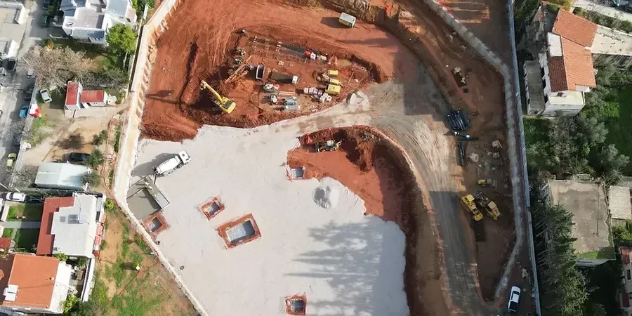
Two summers ago, we were called to a site just off Water Street where a developer planned a three-level underground parkade. The excavation reached 11 meters, and the upper 4 meters were dry, compact till — great material. Then we hit a silty layer with artesian pressure that turned the bench into mud within a shift. That scenario is more common here than people admit, especially between Knox Mountain and the lake, where buried channels redirect groundwater in unpredictable ways. For a deep excavation design, we modeled the wall using beam-spring analysis in WALLAP, incorporating lateral earth pressures from the
in-situ permeability data we collected at three depths. The shoring solution combined soldier piles with timber lagging in the dry zone and a secant pile wall where the silt appeared. We also cross-checked the basal stability using the
CPT test results to confirm the clay content was not over-consolidated enough to prevent a bottom blowout. In the Okanagan, you cannot separate the excavation design from the hydrogeology — they are the same problem.
Regional considerations
Kelowna sits just 344 meters above sea level, with a population that has surged past 150,000, driving construction into steeper slopes and deeper basements. The Okanagan Valley’s seismic setting is not as aggressive as coastal BC, but the 1872 North Cascades earthquake and the 1949 Puget Sound event are reminders that crustal shaking reaches this far inland. A deep excavation without adequate seismic earth pressure coefficients in the design can suffer wall distress during a moderate event, especially in the silty units prone to cyclic softening. The risk is compounded by the spring freshet, when Okanagan Lake rises and groundwater recharge pushes pore pressures to their annual peak. A basal heave failure in a saturated silt layer can propagate in minutes, and we have seen near-misses on sites where dewatering was underestimated. Our designs include redundant dewatering triggers and real-time monitoring benchmarks tied to the excavation monitoring plan, so the contractor knows exactly when to stop digging and when to pump.
Common questions
What is the typical cost range for a geotechnical design of a deep excavation in Kelowna?
For a typical commercial excavation in the Kelowna area, the geotechnical design scope — including site investigation, shoring analysis, dewatering recommendations, and construction-phase monitoring specifications — generally ranges from CA$2,890 to CA$11,740. The final figure depends on the excavation depth, the complexity of the groundwater conditions, and whether 2D or 3D finite element modeling is required.
How does the glacial till in Kelowna affect the choice of shoring system?
The dense, over-consolidated till provides excellent stand-up time in the dry, but its high cobble content can make driven sheet piles impractical. We typically specify soldier piles drilled with rock augers or secant pile walls. The till's high friction angle also allows for shorter anchor bond lengths compared to soft clay sites.
What lateral earth pressure distribution do you use for a deep cut in lacustrine silt?
For the glacio-lacustrine silts found in the Kelowna basin, we do not use a simple triangular distribution. Because these silts are often normally consolidated and sensitive to pore pressure changes, we apply a trapezoidal pressure envelope for the temporary case, with the upper bound derived from the undrained shear strength. For the permanent wall design, drained parameters govern and we account for the full hydrostatic pressure.
How do you handle seismic design for temporary shoring in Kelowna?
Even for temporary works, NBCC 2020 requires us to consider seismic earth pressures if the excavation remains open longer than 12 months or if it is adjacent to a post-disaster building. We use the Mononobe-Okabe pseudo-static method, adjusting the horizontal acceleration coefficient for the site class determined from the shear wave velocity profile. In the silty layers, we also check the potential for cyclic softening using the procedure outlined by Boulanger and Idriss (2007).